Finding missing projection
ProjPicker can be used to guess the projection of data whose spatial reference information is missing for some reason (e.g., a Shapefile with no PRJ file). For example, we can create a Shapefile (Atlanta_GA.shp) for Atlanta, Georgia, and deleted its PRJ file to simulate missing metadata. Only the filename gives the user a hint about its geographic location, but without the PRJ file, novice GIS users can have difficulty finding the right projection and repairing the Shapefile. When the file is opened in a GIS, it will be located far away from the true data location because projected coordinates are treated as latitudes and longitudes.

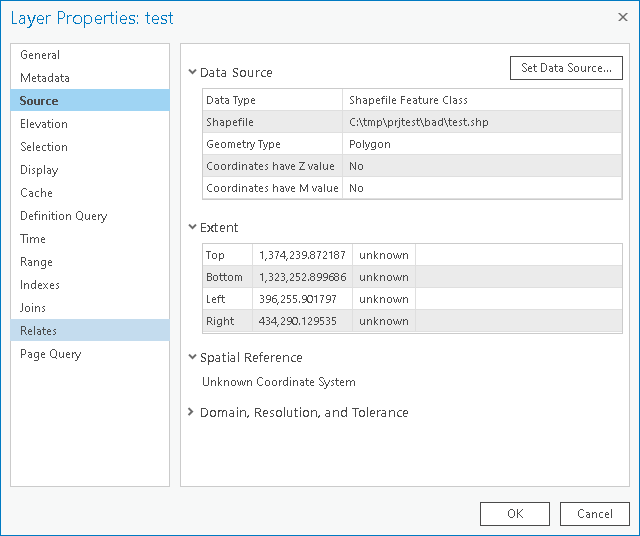
Shapefile location with its projection data removed
Nigeria is definitely not the right location, so the user can search for the latitude and longitude of Atlanta, GA (33.7490°N,84.3880°W) and check the extent of the Shapefile from the layer properties (1323252,1374239,396255,434290 in SNWE):
Extent of the geometry
As can be seen in the screenshot, the spatial reference is unknown. Let’s use ProjPicker to guess it.
We can construct the ProjPicker query string xy bbox 1323252,1374239,396255,434290 latlon point 33.7490°N,84.3880°W and use it as so.
Shell
projpicker -n xy bbox 1323252,1374239,396255,434290 latlon point 33.7490°N,84.3880°W | head -1
This command line does not print the header line (-n) with column names to print only the first selection that is the most localized CRS to the query information.
It then switches to the xy coordinate system and specifies the extent as bbox 1323252,1374239,396255,434290 followed by a point in latitude and longitude for Atlanta latlon point 33.7490°N,84.3880°W.
The head -1 pipe prints the first CRS only.
Remember, ProjPicker outputs are sorted by area from the smallest (most local) to largest (most global).
Python
import projpicker as ppik

bbox = ppik.query_mixed_geoms("""xy bbox 1323252,1374239,396255,434290
                                 latlon point 33.7490°N,84.3880°W""")
ppik.print_bbox(bbox[0])

# or
bbox = ppik.query_mixed_geoms(["xy", "bbox",
                               [1323252.0, 1374239.0, 396255.0, 434290.0],
                               "latlon", "point",
                               [33.749, -84.388]])
ppik.print_bbox(bbox[0])
Results
The final output looks like:
projected_crs|NAD27 / Georgia West|EPSG|26767|EPSG|6602|EPSG|2190|30.62|35.01|-85.61|-82.99|227321.736222316|1825636.8909584181|45969.582735703174|870089.0814069586|US foot|119521.02819197961
The first EPSG code (EPSG:26767) is a CRS code, and the second and third ones are usage and extent codes, respectively. The name of the CRS is “NAD27 / Georgia West”. EPSG:26767 is actually the correct CRS:
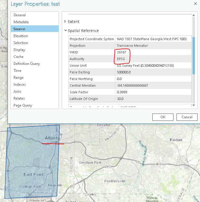
Correct spatial reference